ANDES / CHILI
Ou comment le couplage sur la subduction induit sur le long terme la surrection et l'érosion de la chaîne chilienne et de la chaîne andine.

La zone de subduction du Chili est l'une des plus sismiques du globe.
La sismicité

****The North Chilean subduction, accommodating a convergence rate of 79 mm/yr, was identified as a mature seismic gap that did not break since 1877 (latitudes 18°S - 23°S). Since then, it has accumulated up to 10m of slip deficit. It constitutes therefore an ideal area to study mechanisms of preparation of a future large subduction earthquake. On November 14th 2007, a Mw7.7 earthquake occurred on the southern 150km long segment of this seismic gap.*****
Lien vers le réseau GPS du Chili
Sur la figure : ****Large subduction earthquakes along the Peru-Chile trench are represented. Grey ellipse represents the approximate extent of 1877 historical event. Green rectangle represents the approximate extent of the Mw7.7 2007 Tocopilla earthquake. cGPS stations in the study area are shown, as well as campaign benchmarks (yellow circles).****
Tectonic Summary
Magnitude 7.8 TARAPACA, CHILE
Monday, June 13, 2005 at 22:44:33 UTC
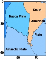
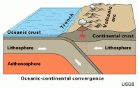
This earthquake resulted from the release of stresses that were generated by the subduction of the oceanic Nazca plate beneath the South American plate. In this region, known as the Peru-Chile subduction zone, ongoing subduction occurs at a rate of about 7.8 cm/year in a east-north-east direction. The subduction process generates numerous earthquakes and volcanism, and actively builds the Andes mountains.
Subduction zones produce the biggest earthquakes on the planet. The largest earthquake of the past 100 years, the magnitude 9.5 1960 Chilean earthquake, occurred in the Peru-Chile subduction zone. The 1960 Chilean earthquake ruptured a 900-km long swath along the Chilean coast about 2000 km to south of the June 13, 2005 earthquake. The devastating December 26, 2004 Sumatra-Andaman Island's earthquake and tsunami occurred in a subduction zone in the Indian Ocean. Those and others of the very largest subduction zone earthquakes were thrust-fault earthquakes on the interface between the subducting plate and the overriding plate, and much of their seismic energy was the result of faulting at depths of 50 km and less . The earthquake of June 13, 2005, by contrast, occurred within the subducted Nazca plate rather than at the interface between the Nazca plate and the South American plate, and it occurred at a depth of about 100 km.
Centro Sismologica de Tarapaca (en español)
Historic Earthquakes in Chile (Site USGS en Anglais)
Magnitude 7.8 - TARAPACA, CHILE (Site USGS)
2005 June 13 22:44:33 UTC
A major earthquake occurred at 22:44:33 (UTC) on Monday, June 13, 2005. The magnitude 7.8 event has been located in TARAPACA, CHILE.
Magnitude 6.3 - TARAPACA, CHILE
2008 February 04 17:01:29 UTC
Magnitude 4.9 - OFFSHORE TARAPACA, CHILE
2008 April 17 07:57:18 UTC
Magnitude 6.7 - ANTOFAGASTA, CHILE
2007 December 16 08:09:19 UTC
Magnitude 7.7 - ANTOFAGASTA, CHILE
2007 November 14 15:40:50 UTC
********
Magnitude 7.1 Near Coast of Northern Chile
1998 January 30 12:16:08 UTC

Institut de Physique du Globe de Paris - Mise à jour 11/2024
Site publié avec e-Lectron - Contact : Webmaster IPGP